In the context of an information system
The Directorate of the Northern Sea Route is leading a project to create drones to monitor the ice situation. It is part of a unified information ecosystem aimed at simplifying and speeding up navigation along the Northern Sea Route. The unified information ecosystem will consist of four components: a satellite constellation, on-board complexes, drones and a single digital services platform (EPTS) and a data bank where all information will be accumulated.
The first stage of the EPCC will be commissioned in early 2024, the second will be ready by the end of 2024 and commissioned in September 2025.
Roscosmos is responsible for the satellites. In May, the Condor-FKA satellite entered orbit, and in June, Meteor-M. Both are equipped with radar equipment that allows for all-weather monitoring of the ice cover. In total, Roscosmos plans to launch nine satellites in 2023. So far, the satellite data is too “dotted” — long time pauses do not allow us to obtain complete data on the ice situation along the route of icebreakers along the NSR.
The onboard complexes were tested on the icebreaker Ural in the winter of this year. The main component of the installation is lidar, which is a space—scanning laser. The complex measures ice cohesion, hummockiness, ice thickness, width of the shipping channel and the rate of convergence of its edges. As of the end of September, the Directorate of the Northern Sea Route is preparing a technical specification for the purchase of a series of five on-board complexes.
The complex provides information about the state of affairs at the place of passage of the icebreaker, but not about what lies ahead at a distance of several hundred kilometers. It is this data that the drones will collect. Their task is to move away from the launch point (icebreaker) at a distance of up to 200 km, climb to a height of up to 2 km and transmit radar images to the control station, where data is processed and translated into an easy—to-understand form using a special algorithm.
Drone Features
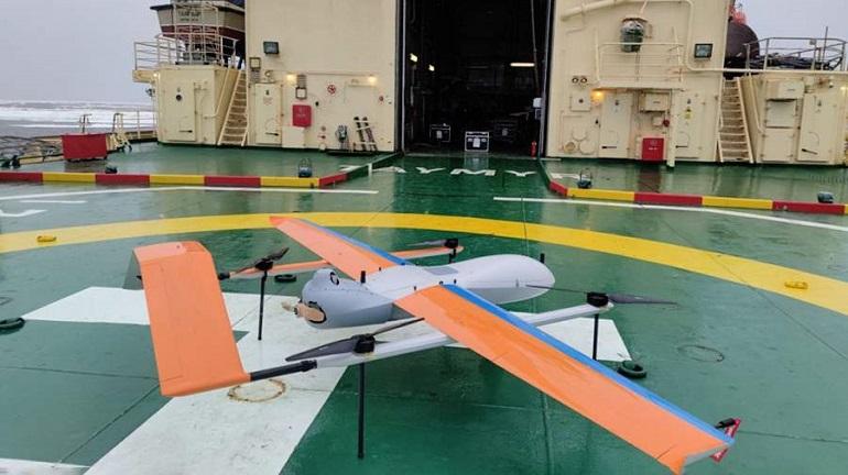
MIPT took the drone of a technology partner as a basis and deeply redesigned it. In particular, he replaced the fuselage parts, the power plant, the fuel system and the control system. The device combines the features of an airplane and a quadcopter in its design. From the first one, he got wings and a tail unit with control devices. From the second there are four screws in the horizontal plane for vertical ascent and descent.
The weight of the tiltrotor with equipment is about 60 kg, the wingspan is 4 m. When folded, it fits into a drawer the size of a desk. The tiltrotor runs on regular gasoline, the tank is designed for four to five hours of flight. The take-off and landing propellers are powered by batteries. The drone can withstand wind speeds of 20 m/s during takeoff and landing, low temperatures and precipitation. The main danger for it, as for other aircraft, is icing.
A synthesized aperture radar is installed on the drone. Synthesized aperture is a method for obtaining highly detailed radar images using a virtual antenna created during the flight of a drone and using complex mathematical algorithms for data processing. The radar captures a 10 km wide band. Taking into account the return path, the operator receives an image with a width of 20 km.
The principle of operation of the drone is as follows: every few seconds it transmits radar images to the control station. The station consists of two computers: the pilot sits at one, and the operator who receives the image sits at the other. The processed data is then transmitted to the geographic information system server, where the type and characteristics of the ice are recognized and a forecast is made. Ice maps are being formed, and the optimal route is proposed to the ship’s captain.
Test starts

The system has already passed two stages of testing. The first ones were held at the Rybinsk reservoir. The reservoir was chosen because it is large, there are strong winds on it, and in February the surface is covered with snow and ice. Not the Arctic, of course, but the first approach to it. In addition, there are islands with trees on the reservoir, according to the clarity of the images, the quality of data transmission and processing was assessed.
The device rose with a wind of 12 m/s by 1 km, flew 70 km and landed at a given point. Thus, the tests confirmed that the drone is working and even at a great distance it is well controlled, the data is transmitted to the control station. After the first tests, the design was improved. The batteries for takeoff and landing were placed in a heated container. A fairing with shutters and a temperature controller was installed on the engine. it doesn’t work correctly.
The second stage of the tests took place at the end of June on the icebreaker Taimyr. At first, they planned to check the drone from the shore of the Gulf of Ob. But when the time came, it turned out that departures from the shore were difficult, so they decided to test it right on the icebreaker.
One of the tasks was to check how the drone would behave on a huge metal object that has its own electromagnetic field and a lot of equipment. The re-reflection of radio waves and navigation signals, communication channels and electromagnetic noise could interfere with the drone’s operation. Plus the Arctic cold and wind and the difficulties of space navigation — communication with satellites in these latitudes is unstable. The developers are proud that they were able to create a working unmanned complex suitable for ice exploration in the Arctic.
Looking ahead
The next task that the developers set themselves is to create an automatic drone landing system. As Dmitry Obukhov, Deputy executive director of the STC for Environmental Monitoring and Ecology at MIPT, explained, the car should automatically take off from the helipad, fly along a route determined by the captain and transmit images, and then return and land on its own. The operator’s concern will only be to fold it and put it in the garage.
“Automation will more reliably adjust the operation of the device, which is affected by wind, pitching and other factors. It is better to exclude the human factor. However, if some kind of emergency situation arises, the operator will be able to intercept control,” Dmitry Obukhov comments. The control of the drone should eventually become so simple that one of the employees of the nuclear icebreaker could handle it after training.
The final tests of the system will be held in November. Then there is a serial order, certification or conformity assessment (unlike certification, it does not consider a type, but a specific device). After the start of regular use, late approval of the flight assignment may become a problem.
“Our task is to get permission to take off from a ship in a certain area almost instantly. To date, it is necessary to submit information in three to five days with a rather unclear result,” Maxim Kulinko said, speaking at the WEF, and proposed making the Northern Sea Route a pilot territory where an accelerated mechanism for issuing flight permits could be worked out.
Atomflot By Irina Dorokhova


