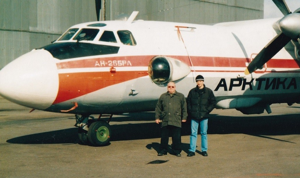
AN-26BRL “Arctic” in Arkhangelsk airport, Nikolai Kuznetsov and Roman Klepikovsky are participants Harp seal aerial survey expedition in the White Sea.
A lot of tasks to be performed
The unique AN-26BRL Arctic marine air laboratory was developed on the basis of the AN-26B aircraft. It was created as a follow-up to previous developments of the IL-14, IL-18D air laboratories and avionics equipment complexes for AN-32, L-410 aircraft commissioned by the Polar Institute (PINRO, Murmansk) under the general guidance of Chernooka V.I.
The air laboratory was used to study the distribution of fish stocks in the seas of the North European Basin, the Greenland seal in the White Sea, and the distribution of oceanological and hydrobiological parameters on the sea surface.
The aircraft was also used for search and rescue operations and is painted in the colors of the polar Aeroflot, and the inscription “Arctic” is applied to the fuselage. The AN-26BRL has additional fuel tanks that provide a flight duration of up to 8 hours over the sea.
The main technical characteristics of the laboratory aircraft:
– the maximum flight length is 1,500 nautical miles;
– the maximum flight duration is 9 hours;
– the average speed during aerial photography (at an altitude of 150-200 m) is 170 knots;
– the maximum take-off weight is 25 tons.
Comprehensive aerial surveys of the seas, led by V.B. Zabavnikov, were conducted along a grid of tacks oriented across the jets of the main currents. The distance between the main survey tacks did not exceed 45 m. miles, and in places of maximum variability of oceanological parameters 20 m. miles.
The laboratory aircraft was also used to assess the environmental situation and air accounting of seabirds under the leadership of A.A. Shavykin.
In the late 1990s and early 2000s, the marine air laboratory was used for aerial photography of the Harp seal and lineal deposits in the White Sea. Based on the materials of aerial surveys, the number of offspring and the entire White Sea population of the Harp seal was estimated. Vasiliev A.N. – technical supervisor, Kuznetsov N.V. – methodical supervisor and Shafikov I.N. – automation of animal counting took an active part in the work.
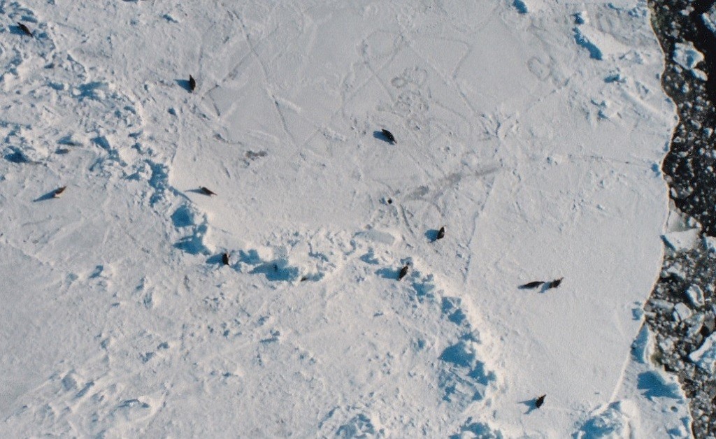
A fragment of an aerial photograph of a harp seal deposit in the White Sea.
Passive aerial photography equipment
The following passive sensing equipment was used during aerial surveys on board the Arctic laboratory aircraft.
The complex of sensing in the infrared (IR) range of electromagnetic wavelengths included the IR radiometer AIR-2 and the IR scanner “Malachite”.
The AIR-2 and the IR scanner made it possible to measure the temperature of the ocean surface (TPO) continuously, with an accuracy of at least 0.1 °C. According to it, the spatial structure of the TVET was restored on the basis of standard interpolation methods, taking into account knowledge about the thermal and dynamic features of the aerial survey area.
The Malachite thermal imager made it possible to obtain information about thermal conditions in local areas of the sea surface based on the analysis of infrared images. This made it possible to identify the position and structure of thermal inhomogeneities on the sea surface, as well as organic pollutants in the form of spots and films.
In addition to using instrumental aerial photography systems, visual observations were carried out from the aircraft. Each researcher performed sideways observations in the field of view equal to the flight altitude. At the same time, the number and species of marine mammals, birds and other biological objects were estimated, as well as pollution on the sea surface was recorded.
Additionally, photo and video recordings of various phenomena, effects and objects on the sea surface were carried out in order to document them.
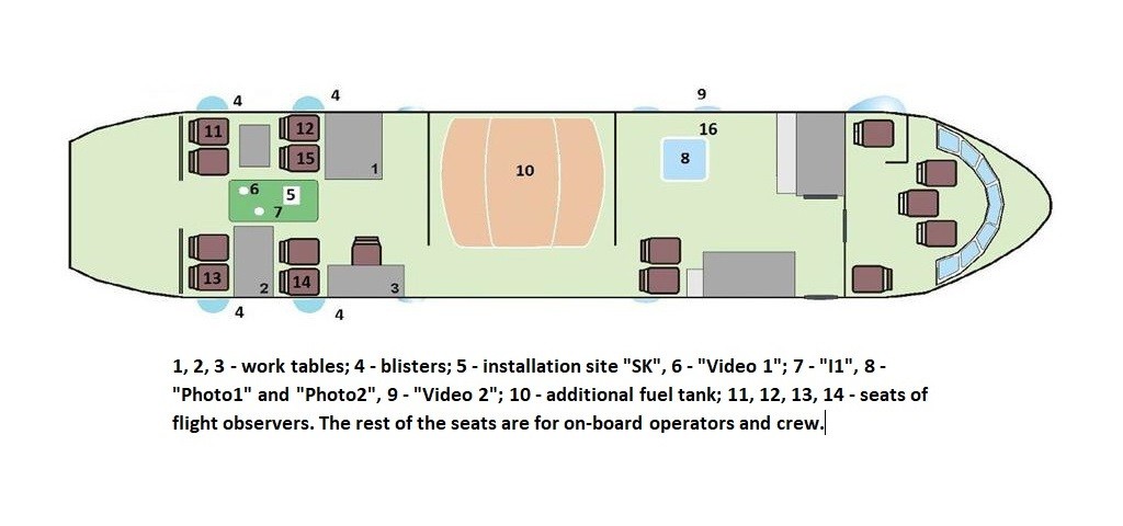
The layout of the equipment in the cabin of the AN-26BRL aircraft.
Active air sounding complexes
The ultrahigh frequency aviation sounding complex (microwave complex) was represented by a radar with a synthesized aperture of RSA-4 (radiation wavelength – 4 cm) and a passive microwave radiometer with an received radiation wavelength from the sea surface of 5.6 cm.
The main feature of the microwave complex was the possibility of its reliable use in all weather conditions. The complex made it possible to obtain information about the position and structure of hydrodynamic inhomogeneities, the boundaries of water masses of various origins on the sea surface, organic pollutants in the form of spots and films.
At the same time, the microwave complex made it possible to receive data in the form of radar images in a viewing band of at least 2 km. The microwave radiometer measured the values of the radio brightness temperature, the analysis of which made it possible to determine the position of the boundaries between water masses of various origins and identify organic pollutants.
The laser location complex was represented by a polarizing aviation lidar – PAL-1, which probed the subsurface layers of the sea in the optical range of electromagnetic wavelengths. The depth of penetration of the beam into the water column depended on its transparency and averaged 30-40 m for clean oceanic waters.
The use of PAL-1 made it possible to obtain not only data on the values of oceanological parameters on the sea surface and in subsurface layers, but also to register organic pollutants on the sea surface.
All the information received was fed into the on-board automated data collection and primary data processing system with simultaneous recording of all voice information of observers in the dictaphone mode. A satellite navigation system was used to link all data to real coordinates and time.
A local network was organized on the laboratory aircraft, connecting all on-board computers, which allowed data exchange between them and time synchronization of all systems on board the aircraft. The possibility of operational data transmission and exchange with naval vessels and coastal centers was also implemented.
Further, the resulting information was promptly communicated to consumers both at sea and on shore.
Maximus Reprinted with abbreviations.

