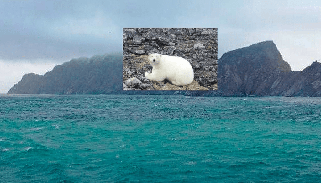
Firnlea Island. Polar bear on the island
Small unmanned aerial vehicles (UAVs) have gained high popularity as expedition equipment. The range of expeditionary tasks that can be quickly solved with the help of a standard UAV camera is quite wide: operational reconnaissance on the ground, inspection of dangerous and hard-to-reach locations without the need to put people at risk, determining optimal routes of movement over rough terrain or in conditions of hummocks, early detection of wild animals and other tasks.
Some aspects of the tactics of using UAVs in difficult conditions of Arctic expeditions are described here, based on the experience gained, the results obtained are presented and the nuances of photogrammetric image processing are analyzed. The overview part of the article demonstrates the range of tasks that can be solved using UAVs in Arctic expeditions, and the substantive part is devoted to determining the features of optimal processing of the received data.
One of the tasks of the expedition was to inspect the condition of structures on the shores, but not always weather conditions, the state of the shore or the time reserve allowed the group to land for work. In such cases, we had to limit ourselves to remote inspection using a quadcopter launched directly from the icebreaker. It is worth noting that launching a quadcopter from a ship involves significant risks: navigation errors and ship drift can lead to the crash of the aircraft and its loss.
Another task assigned to the hydrographic group was to clarify the coordinates of geodetic signs and lighthouses. In some cases, these objects were located at a distance of several kilometers from the area of the main work of the expeditionary force, so it turned out to be extremely effective to use a quadcopter to approach the object, fix the position exactly above it and determine the coordinates using the standard positioning system of the drone.
Drones proved to be a great help to ensure the safety of the expedition team’s work – each landing began with a flyby of the nearby territory to check the presence of wild animals, the most dangerous of which were polar bears. Several times, it was the observation with the help of a quadcopter that made it possible to notice the approach of predators in time. Also, observation from a height helped to determine the area of the coast with the least number of pitfalls for a safe approach of the boat.
The results of photogrammetric processing are also of great importance for geological and geophysical work, since they allow us to obtain a digital relief model (DEM) and an orthophotoplan used in the field of geophysics, geodesy, geology, glaciology, oceanography and other Earth sciences. Thus, with the help of aerial photography, it was possible to identify active fault zones in many areas of expedition work.
Satellite images are usually used for this purpose, but they have insufficient resolution and overlap compared to drone images. Therefore, satellite images are used for planning work, and drone images are used for a detailed study of the area.
Methods and results of aerial surveys
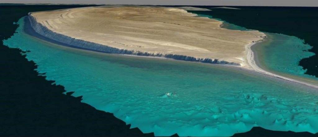
A three-dimensional model of part island Timofeeva superimposed on a satellite image.
The primary photographic material was obtained using a quadcopter with a standard camera on a stabilized suspension. Depending on the illumination, a light filter was selected to ensure high contrast of the images. The drone was controlled manually using the Smart Controller remote control, which provides an increased data transmission range due to an enhanced antenna and high image clarity.
The processing of photographic materials was carried out in a special Agisoft Metashape software package, which allows, as a result of photogrammetric processing of a series of images, to obtain a digital relief model (DEM), an orthophotoplan and a polygonal three-dimensional model of a relief section or individual objects.
To get a high-quality result, proper planning of the UAV flight and shooting angles is necessary. Shooting should be done with a fixed focal length. If necessary, the images are rejected and the exposure is adjusted before processing. This procedure is especially important for a series of photographs taken with variable clouds, which can lead to uneven illumination of the orthophotoplane.
Another example of applying the results of photogrammetric processing is Belukha Island in the Kara Sea. A young tectonic gap has been identified in the southern part of the island, represented by expressive seismotectonic ditches with a width of 3 to 15 m and ledges. The photo and video material obtained during the shooting of the lighthouse on the island made it possible to build a three-dimensional model of it. The transparency of the water and good weather made it possible to restore the bathymetry of coastal shallow waters.
The coordinate reference of the presented photographic materials was carried out using the standard navigation sensor of the quadcopter. In the Arctic, such a binding may contain large errors due to the lower density of satellites in the Arctic region.
What did the quadcopter help with?
The paper presents three examples of the use of aerial photography using UAVs in the Arctic and subsequent processing by photogrammetry in the Agisoft Metashape software package.
In the first case, when shooting Jeannette Island exclusively from sea level, it was possible to build a relief of coastal steep cliffs and restore the coastline of the island without using specialized equipment.
In the second case, when processing the rich photographic material from Timofeev Island, it is shown that the best result can be achieved when constructing a model of the island from a depth map.
The third case demonstrated that a satisfactory result can be obtained even when using a sequence of frames obtained during video shooting. This, of course, significantly speeds up the field work, but reduces the quality of each image, which cannot be compensated by increasing the total number of photos.
The use of a UAV with a camera allows solving many tasks during Arctic expeditions, saving objects in the form of digital three-dimensional models, conducting operational reconnaissance on the ground, safely exploring locations, determining the optimal route over rough terrain, and preventing encounters with wild animals in advance. Therefore, the use of UAVs is highly recommended in modern expeditions.
By R.A. Zhostkov, S.A. Toschov
The full work was published in the journal “Science and Technological Developments”, 2023, vol. 102, 1, pp. 4-18.

