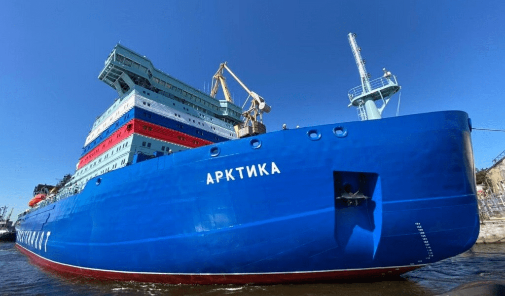
Icebreaker “Arctic” / Photo: Shipbuilder.ru
Research on the ice situation on the Northern Sea Route is an urgent issue of Arctic development. Despite the development of the fleet and radio navigation, ship captains face the problem of assessing the state of the ice field. The company “Inteltech” has taken up the solution of this issue with the help of drones. Professor Sergey Bidenko told about what characteristics they have and what issues on UAVs for the Arctic need to be solved.
— Are drones the main focus of your company?
We have been implementing the unmanned monitoring project for only the third year.
— Are UAVs intended for civilian vessels?
— The sea does not divide ships into military and civilian ones. The marine environment is the same for everyone. It is important for any fleet to know the ice situation in order to safely navigate the Northern Sea Route.
— What are drones for?
— There is always a radar on an icebreaker that sees the ice situation for six miles. Caravans are conducted in the ice fields at a speed of 12 knots, which is about 22 km/h. How long will it take the ship to cover 10 km? Very quickly. And the captain needs to see in advance what is 100-150 km ahead. Then he will be able to determine the safe route of the icebreaker.
It is important to understand that no matter how powerful nuclear-powered ships are, they do not walk directly through the ice fields, because after laying such a path, the channel will quickly tighten. The ship is sailing through streams and polynyas. The main parameters for the passage are the hummockiness and cohesion of the ice. These indicators determine the route of the icebreaker. And no matter what anyone says, the thickness of the ice cannot be determined just by looking at it.
The sooner the drone passes through the crevices and wormholes and makes an accurate map of the ice field, the better it will be for both the captain and the caravan. And then the actions described earlier will not be necessary.
We used to receive information from satellites. After the start of the SVO, difficulties arose: due to sanctions, there was a shortage of satellite images. Now the cosmos provides data once every six hours. There is no such thing as a lot of information, the more channels to receive it, the better. Ships sailing along the Northern Sea Route receive a picture from the naval operations headquarters. Drones are able to solve this issue.
— What size are they?
— Different things. In order to have a simplified procedure for obtaining a flight permit, a fully equipped drone must weigh slightly less than 30 kg. A large mass requires special permits.
The issue of a new regime for obtaining permission for drones has been raised for the second year. Because unfortunately, the radar and other sensors cannot be placed in these 30 kg. We need a heavier car — 50-60 kg. Our cluster partner is currently building a 120 kg UAV to accommodate four components on board: optics, radar, infrared and ultraviolet radiation sensors, as well as a weather station.
Characteristics of the UAV for ice reconnaissance
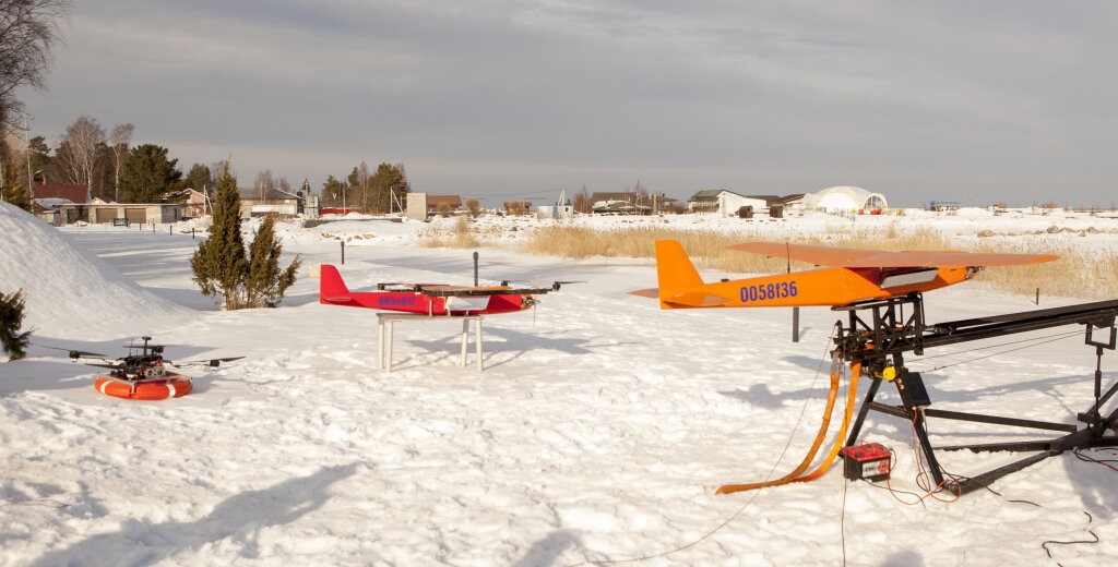
UAV tests / Photo: Sergey Bidenko ????
— How long is the device able to stay in the air?
— Our plane with one radar can hang in the air for six hours at a speed of 100 km/h. This means that he flies 300 km there, 300 km back. Again, if the UAV is heavier, it will be able to fly further away.
If the “plane” immediately found the channel, gave a picture, everything became clear to the skipper, four hours would be enough. But the captain can give the command to fly and scout again in two hours.
— Tell us about the design of your UAV.
— The drone can be divided into two parts. The first is a glider. It performs the function of a physical carrier and its main task is to fly, and to do so in the most difficult conditions of the Arctic. Ideally, it should keep the wind at least up to 25 m/s, the temperature up to -35 C. Ours holds up to 20 m/s.
The second part is the electronic filling: various sensors and control systems. On the NSR, the polar night lasts for eight months, so Atomflot requires information from at least two sensors – radar and optics. Ideally, infrared and ultraviolet sensors should be added, as well as an automatic weather station. The joint use of meters of different physical nature. Then the limitations of some sensors will be offset by the advantages of others.
But here a new problem of information dimensionality arises. One radar outputs approximately 200 Mbps, which require processing. And all this needs to be tied to one process so that we understand that each sensor is talking about one object. The task is solvable, but it takes time.
First, the “plane” needs to be brought to mind so that it can fly in difficult Arctic conditions. And secondly, to work out the cyberphysical information part to the end.
We assume that several types of drones will be created, differing in configuration, weight and range. The UAV designed to be placed on board the vessel illuminates the ice situation at 100-150 km and will weigh 50-60 kg. Regional — will be able to analyze 600-1000 km with a mass of 120 kg. Transarctic — will be able to reveal the situation at 10,000 km and pull 1200 kg.
What UAV issues still need to be resolved?
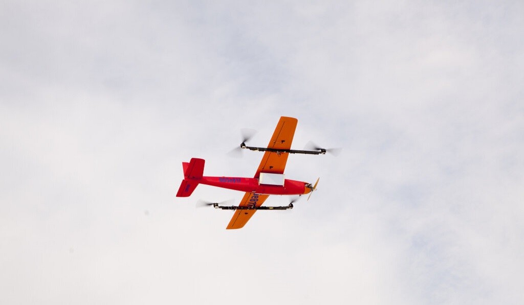
UAV tests / Photo: Sergey Bidenko ????
— How many drones will be needed in the Arctic?
— Now the main demand is generated by Rosatom with its eight icebreakers. There should be two drones on board one: one is broken, the second is working. In addition to the Atomflot directorate itself, there are many other structures that determine the development and financing policy, they have their own views on the situation.
Both aviation and cosmonautics developed through failures. Sergei Pavlovich Korolev launched a rocket with a man on board with a 50% probability of success. Low temperatures, wind, icing — to create an optimal Arctic drone, it is necessary to solve many scientific and technical issues.
— Who will control the UAV?
— It takes three people to operate it. But it is possible to assign these duties to trained icebreaker crew members.
— Are there many domestic components in the UAV?
— The question is not very funny. Unfortunately, the drone engines are imported. Today, there are barriers to their supply that have to be overcome. We buy chips in Southeast Asia. The “plane” itself, the control system, and the radars are ours.
— And as for the navigation equipment?
— We use GLONASS and GPS. Interference, plus small signals, results in a bad picture.
If you open the radio navigation plan of the Russian Federation, there are ground-based radar stations that are promising for coordinate support in the Arctic.
At one time, there were three Mars radio navigation systems with a range of 1000 km throughout the Northern Sea Route, since space communication is weak in the North. Similar modern systems exist and could be deployed on the NSR.
The industry offers such analogues in a new version. But in order to use them, the shipowner will have to buy additional sensors of these systems and install them on ships. This is an additional cost, and skippers prefer to use space.
— Do you have competitors in Russia?
— The Directorate of the Northern Sea Route, represented by the organization Greenatom JSC, conducted a market study of manufacturers of unmanned vehicles and examined the products of different companies. It turned out that 400 Russian manufacturers have the ability to produce drones. But 90% of them are just resellers. MIPT drones are also highly appreciated. We try to build creative partnerships with them.
Shipbuilder

