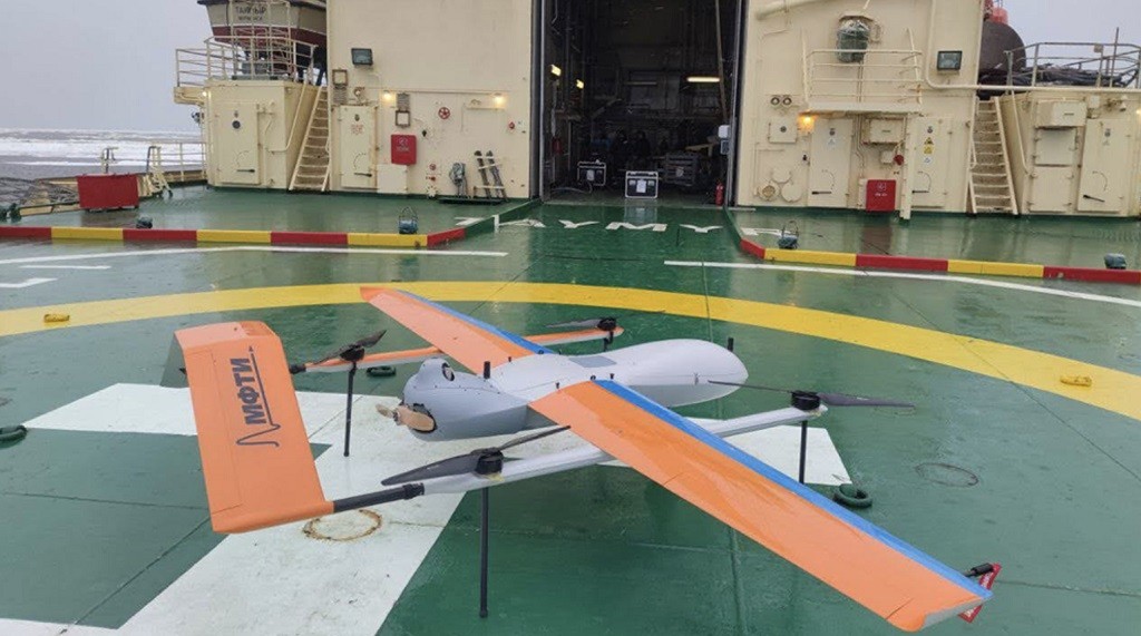
A drone on board an icebreaker © Industry publication of the Rosatom State Corporation
Arctic conditions impose special requirements on any equipment — it must be resistant to corrosion caused by seawater, withstand wind gusts and extreme temperatures. In addition, navigation in the Arctic Ocean is complicated by frequent magnetic storms and poor coverage of remote sensing satellites. This was told by the chief specialist of the AANIA Oleg Devyataev.
He explained that the Arctic UAVs created in Russia can replace helicopters, which are now often used from icebreakers to collect navigation data. At the same time, the key task that is being solved today is to build up the domestic satellite constellation of remote sensing of the Earth. This is necessary for more efficient development of the Arctic, the scientist explained.
— Rosatom State Corporation has completed testing of an ice reconnaissance complex based on unmanned aerial vehicles. Tell us, please, what does this mean for science and the Russian icebreaking fleet?
— Previously, the biggest obstacle to using UAVs was the difficulty of landing a drone on board a moving icebreaker or vessel in a difficult Arctic environment. However, now we can say that this task, which has been facing developers for a long time, has finally been solved.
I would like to note that today we receive almost all information about the state of the Arctic ice sheet from satellites, because they provide fast and extensive coverage of territories that aviation is not capable of. It will take several hours for the UAV to cover the distance that the satellite flies in ten minutes. Sea ice is very dynamic, and during the flight of such a drone, the ice situation can change significantly. Actually, for the same reason, satellite navigation replaced aviation intelligence at one time.
However, UAVs can be very useful for solving a number of local tasks that are currently being solved with the help of aviation. Currently, all nuclear icebreakers and scientific vessels have a helicopter landing pad. But the helicopter is very expensive to operate: you need a crew, equipment, fuel, etc., and drones can replace it.
The use of UAVs makes it possible to receive information about the ice situation in real time. UAVs can be integrated with on-board measuring complexes (BIC), which collect data on the hydrometeorological situation, on the state of the ice cover directly on board the vessel. Such complexes are now beginning to equip the icebreaking fleet.
— What about the Arctic-M satellite constellation? The first satellite of the group was launched in 2021, and the second in December 2023. Are further launches of this type of satellite planned?
— The so-called geostationary satellites are mainly used for weather forecasting. They are in orbit, the speed of the satellite on which coincides with the speed of rotation of the Earth. This orbit is located at an altitude of 36 thousand km in the equatorial plane. The satellite, which is located at the equator, does not capture the polar regions. Only the equatorial part, moderate latitudes, a little — high latitudes.
The Arctic-M satellites are not navigational, but hydrometeorological. They are placed in a highly elliptical orbit. But it is not circular, but strongly elongated, elliptical. And at the apogee — the highest point — it approximately coincides with the height of the geostationary satellites. And it is precisely in this part of the orbit that the satellite moves very slowly relative to the earth’s surface, which allows it to receive information almost constantly: images are transmitted to Earth every 15-30 minutes.
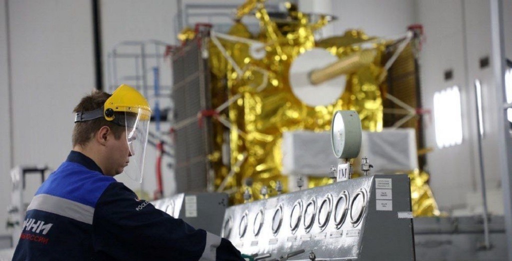
The Arctic-M satellite © Roscosmos
Arctic exploration is necessary for everyone
As for navigation, it is now very important to increase the domestic satellite grouping of remote sensing of the Earth at least up to the number that was during the USSR. This work is underway, it is included in the development plan for the Northern Sea Route until 2035. Thus, the Kondor-FKA radar Earth sensing satellite has already been successfully tested.
— What role does radar equipment play in monitoring the ice situation?
— There are side-view radars and synthetic aperture radars. They have different principles of work.
Optical satellites provide a detailed image, but their operation depends on the clouds. In the conditions of a polar night in the Arctic, we cannot use optical data. And the radar range removes this problem and allows you to receive information regardless of the presence of clouds.
But decoding radar images is much more difficult than optical ones. When monitoring the ice situation, our specialists use the entire set of information that is available: both the optical range and the radar range, data from icebreakers and ships, from polar stations, expeditions. This is the most effective.
In principle, the same equipment is used on UAVs. But if there is a drone on board, the ship’s captain can plan to collect information on his own. When there is a drone on board, it allows you to receive information here and now, thus complementing the information received from the naval operations headquarters and the scientific task force. It should be understood that for Arctic navigation, not only current information is important, but also a forecast for several hours and days ahead.
— What is the main difficulty in designing drones for the Arctic?
— Quite strict technical requirements are imposed on all marine equipment, Arctic UAVs must meet them. That is, in this case, not only flight characteristics are important, but also resistance to marine conditions.
First of all, the weather. Drones, especially those based on board a ship, are relatively light aircraft. Naturally, strong winds can interfere with their work. Another factor is the risk of icing on the wings, blades and rotors. Therefore, the restrictions will be the same as in conventional aviation, and even more stringent. This is the first one.
The second is electromagnetic storms, which very often occur in the Arctic, which can cause communication to be lost. However, this is a less significant factor than icing and wind.
But what plays a really important role is the chemical aggressiveness of seawater. That is, by itself, being on deck and in the air near the sea surface has a very strong effect on the design elements of drones, since exposure to salt can lead to corrosion. It is already very important for engineers to work efficiently here, to take this into account when developing the device.
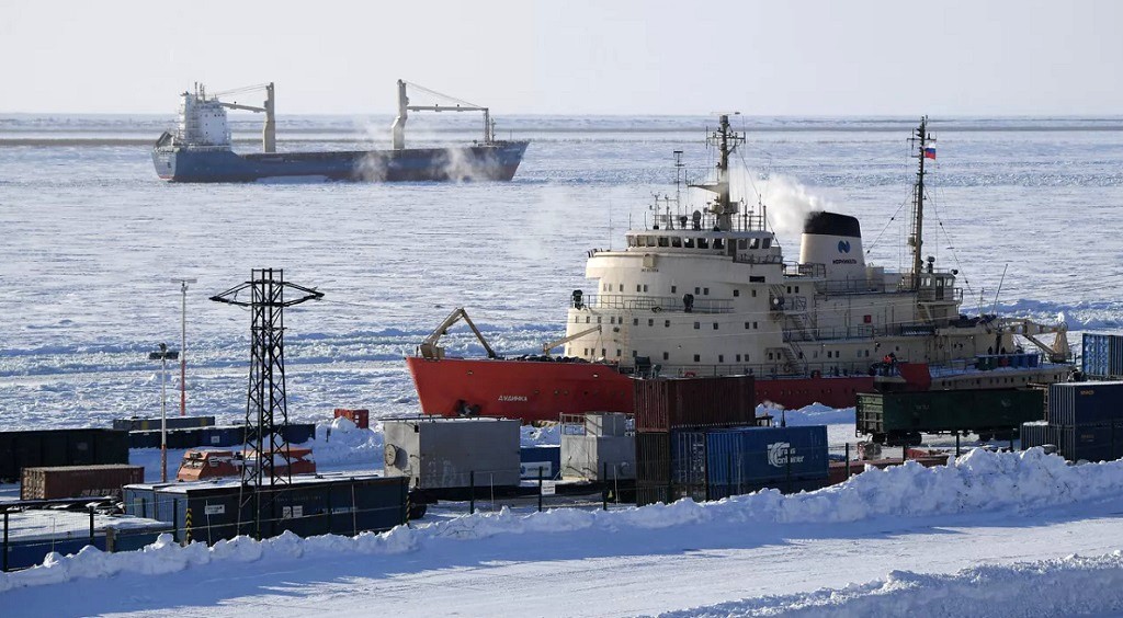
Ships in the Dudinka seaport © RIA Novosti / Svetlana Shevchenko
The main thing is ground-based information processing complexes
— In addition to navigation of icebreakers and other vessels, what other use can Arctic UAVs find?
— Drones are also in demand by ports and oil and gas platforms, the latter can use drones to monitor the situation near their equipment.
In Soviet times, aviation was actively used in the Arctic circle, until it was replaced by satellites. At that time, a very complex and well-coordinated infrastructure operated in the harsh and deserted expanses of the Arctic, including a network of airports and runways, the delivery of aviation fuel and regular quality control, etc. Since the collapse of the USSR, this infrastructure has fallen into disrepair. Therefore, the emergence of Arctic drones as an alternative to aviation will be of great importance.
— What else might be needed for the development of the Arctic? What technologies?
— First of all, it is important to develop a domestic orbital grouping and equip satellites with new instruments. Yes, you can use data from foreign satellites, even during the Cold War there was a global satellite monitoring system for the situation on Earth. Now this system has been preserved in many ways, but you cannot rely on it alone. We need our own, independent grouping of remote sensing satellites.
Secondly, it is necessary to develop a network of ground—based complexes that receive information from satellites. Roscosmos, Roshydromet, and the Ministry of Emergency Situations have their own complexes, but they are mostly located on land and can receive data only in the coverage area of their equipment. Therefore, in order to expand the monitoring coverage, a special complex is needed as close as possible to the pole, where the orbits of remote sensing satellites converge.
In AANIA there is such a complex of three stations on Svalbard, in the village of Barentsburg. This is the territory of Norway, which, according to international agreements, can be used by various countries, including Russia. The complex is managed from St. Petersburg, remotely, and on-site maintenance is provided by one specialist. At the same time, a huge antenna complex of Western countries is located nearby, which receives data simultaneously from all polar satellites.
It would be great for us to build a similar center in the Russian Arctic, our specialists have the competence and experience to do this. The bottom line is that such a complex can collect data from many satellites at once, decrypt and process this information and send it to consumers — to ports, offshore platforms and ships. This would be a good help in the development of the Arctic.
By Nadezhda Alekseeva, Alina Likhota

