Photo: Shutterstock
The Arctic is considered to be the place where the climate of the whole Earth is formed, and it is also one of the most unexplored and undeveloped territories. There are many reasons for this: low temperatures, remoteness from other continents, impassable ice, poor visibility in a snowstorm. Despite these difficulties, the Far North has been attracting researchers from all over the world for a long time, and drones have recently come to help in the development of the Arctic.
According to general estimates, there are 150-200 thousand drones in Russia today, and in the next 10 years their number will increase tenfold. Aeronet National Technology Initiative (NTI) market participants develop, create and implement unmanned aircraft systems in various sectors of the economy: agriculture, logistics, including Arctic exploration.
“UAVs are indispensable for clarifying the data of space ice exploration, determining the speed and direction of drift of icebergs and ice fields, as well as for organizing transport links between board and earth, especially where there is no berthing infrastructure,” Geoscan Group noted.
Ice exploration at short distances
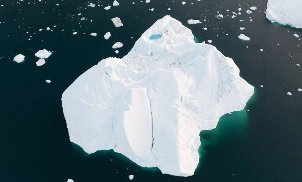
The thickness of the ice in the Arctic can sometimes exceed 2 m. Insufficient exploration will jeopardize the survivability of the icebreaker, since not every vessel is able to overcome such thick ice. Radar data from satellites are usually used to monitor Arctic waters, but there are no such devices in the Russian space group.
The NTI Competence Center “Artificial Intelligence” on the basis of MIPT has developed complexes with drones that can carry out reconnaissance at short distances of 100-150 km.
In addition to the drone itself, the complex includes:
radar equipment;
Software for the synthesis and processing of radar images;
tools for recognizing and predicting the ice situation;
decision support system.
Alexander Rodin, Director of the Scientific and Technical Center for Environmental Monitoring and Ecology at MIPT: “We have developed neural networks that analyze radar data and read the characteristics of ice formations. This should be done because age, the cohesion of the ice formations, can affect the route of the vessel.”
Similar developments are underway at NPP Radar MMS JSC. Small-sized X-band radar stations are installed on board the aircraft. They provide up to 3,000 km2 of radar imagery per flight, depending on the duration of the carrier’s flight. The company plans to complement the ice exploration complex with a remote ice thickness meter.
Ivan Antsev, Executive Director of the company “Radar MMS”: “Now our scientists have an even more ambitious goal — to adapt the complex to sea ice. The fact is that salty ice, unlike fresh ice, is a complex dielectric, which, in addition to ice crystals, includes air, brine and a number of other components, which seriously complicates the task of measuring its thickness.”
Search and rescue of people, cargo transportation
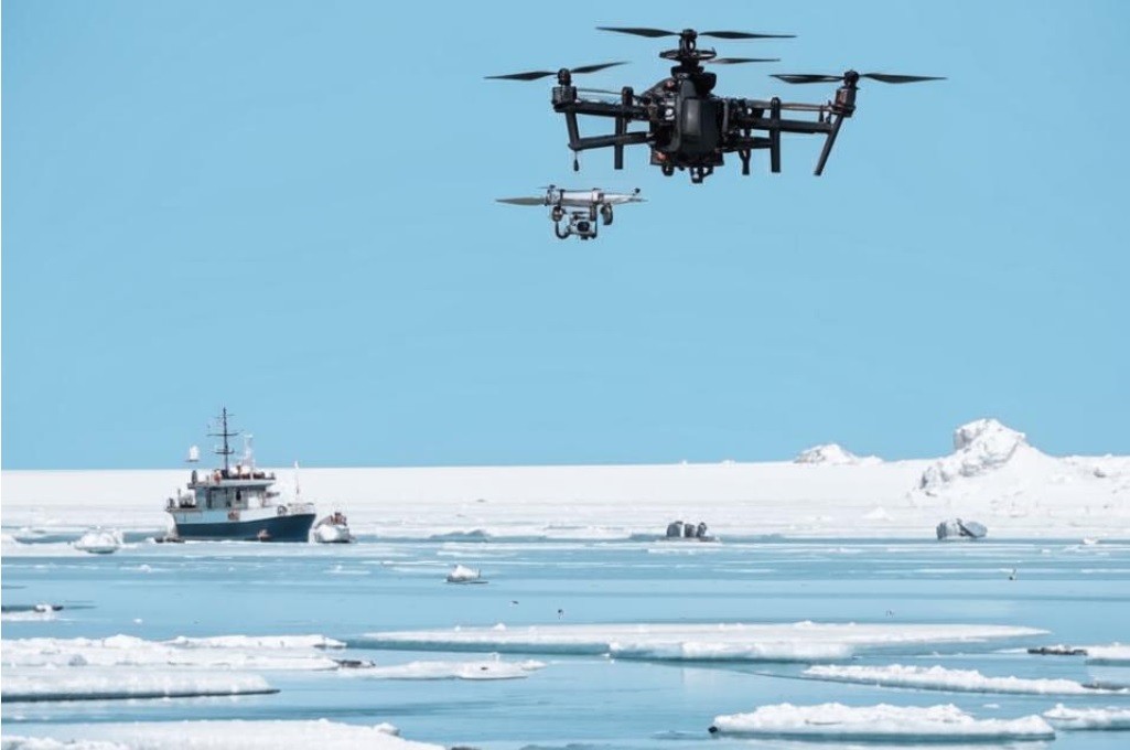
In 2019, SkyStream presented the SeaDrone drone. Its functionality ranges from probing the earth to rescuing drowning people. In 2021, it was tested in the Kara Sea. Despite wind gusts that reached 18 m/s and waves up to 1.5 m high, the drone performed a safe takeoff and landing from the deck, conducted a search and rescue operation for drowning people, and also took water samples.
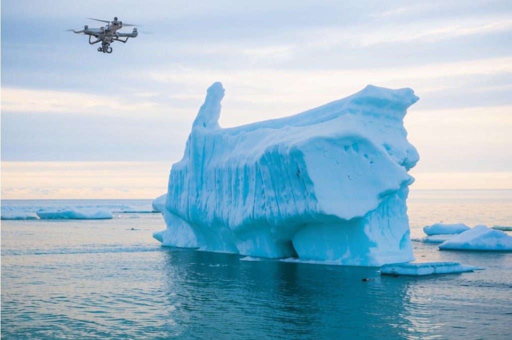
Vyacheslav Barbasov, CEO of SkyStream, said: “In 2023, we plan to use SeaDrone in several expeditions. The main tasks are iceberg marking and water monitoring for oil spills. The drone can also carry out search and rescue of drowning people. It records that a person is overboard, flies up to him, lands nearby or drops a life jacket.”
The Geoscan 401 unmanned complex successfully copes with similar tasks. The SeaDrone and Geoscan 401 drones are equipped with automatic landing systems, video cameras, thermal imagers and lidars, with which they can monitor the ice situation and install beacons on icebergs.
Aeromax has created two civilian unmanned helicopters SH-450 and SH-750. They can stay in the air for 6 and 5 hours, respectively. Helicopters carry out vertical takeoff and landing, which allows them to be used in hard-to-reach areas and unprepared sites.
In addition, Aeromax produces target loads for ice exploration and search operations. A gyrostabilized optoelectronic system is installed on board the drone and helps to determine the structure, texture and physico-mechanical properties of snow and ice covers, as well as to conduct a detailed survey of the relief of the ice surface.
Scientific goals
The Arctic is of great scientific interest. Drones can track populations of fish, bears and other inhabitants of the Far North. In 2020, the Geoscan 401 unmanned complex was used in a joint expedition of the Lomonosov Moscow State University Marine Research Center and the Severtsov Institute of Ecology and Evolution of the Russian Academy of Sciences, organized by the Rosneft Arctic Research Center.
“The device was used for reconnaissance, searching for rookeries of walruses and polar bears, counting animals, studying their condition and behavior. The expedition members conducted flights of the Geoscan 401 UAV on the Great Orange Islands, the northernmost group of islands of the Novaya Zemlya archipelago in the Barents Sea,” the Geoscan press service said.
The head of SkyStream noted that drones can be useful for environmental purposes: tracking animal populations and monitoring the overall environmental situation. Thanks to artificial intelligence systems, SeaDrone can detect debris and oil spills.
Vyacheslav Barbasov said: “SeaDrone tracks red Book animals, for example, beluga, blue whale, narwhal, polar bears. This is necessary both to record data on the population of animals, and to warn about the approach of a shark to a ship or shore, for example. Technical vision allows the drone to detect debris and the state of the water in the sea. Such monitoring is the most effective.”
By Maria Korenkova

